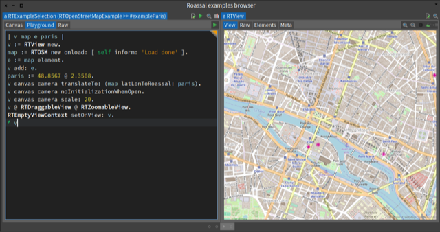
Nice city in addition I love Quartin Latin :) On Sun, Feb 11, 2018 at 9:26 PM, Sven Van Caekenberghe <sven@stfx.eu> wrote:
On 10 Feb 2018, at 19:00, Stephane Ducasse <stepharo.self@gmail.com> wrote:
Sven in Roassal you can see them in the examples menu.
Ah, and it all works out-of-the-box just-like-that in Pharo-7.0+alpha.build.493.sha.d53a70bc946ed83b046f61ac35f00c67fa77269a (32 Bit) on macOS.
Wow, amazing ! Very, very nice.
On Fri, Feb 9, 2018 at 10:20 AM, Cédrick Béler <cdrick65@gmail.com> wrote:
Thanks all,
Iâll give a try to roassal so.
Cheers,
Cedrick
Le 9 févr. 2018 à 08:59, Thierry Goubier <thierry.goubier@gmail.com> a écrit :
2018-02-09 7:50 GMT+01:00 Sven Van Caekenberghe <sven@stfx.eu>:
On 9 Feb 2018, at 06:40, Thierry Goubier <thierry.goubier@gmail.com> wrote:
Le 09/02/2018 à 00:46, Arturo Zambrano a écrit :
I used Roassal + OSM and worked perfectly (2 year ago at least). Although I think there is no support for something like a tiles cache.
We did the OSM support with an in-image tiles cache, but limited to the current map section being viewed.
It would be easy to add an on-disk cache to that code.
Thierry
On Thu, Feb 8, 2018 at 7:46 AM, Cédrick Béler <cdrick65@gmail.com < mailto:cdrick65@gmail.com <cdrick65@gmail.com>>> wrote: Hello, I would like to have a representation of a map in the image to show (my) GPS coordinates. I havenât really tried nor searched yet but Iâve seen Roassal examples that could do the job, especially the Open Street Map integration. So does people here have advices on how to to that (having a morph that shows a map and positions) ? Ideally I would like to have it work offline (meaning I download first tilesâ¦or a vectorized map would do the job too). TIA, Cédrick
Thierry,
Where are the load instructions ? Does it still work for Pharo 7 ?
It should still be part of Roassal, with some issues with the data sources used to retrieve cities coordinates (they went offline!).
I haven't started working with Pharo 7 yet, so I can't say.
Thierry
Sven