New builder for Roassal: building geographical maps

Hi! During our pair coding session on Friday, we worked on a new builder for Roassal. Here is short example: | builder | builder := ROFranceMapBuilder new. builder shape circle size: 15; color: Color red; withLabel. builder showCities: #('Paris' 'Lyon' 'Marseille'). builder shape circle size: 25; color: Color blue; withLabel. builder show: 'Nice'. builder open It should produce: There is no reference to external files. It runs out of the box. In case you got a sudden need to press a like button or do some retweet, here a bit of material: https://www.facebook.com/media/set/?set=a.543459092407359.1073741830.3405434... https://twitter.com/objectprofile/status/401433558684008448 On our facebook account we have many more screenshots. Cheers, Alexandre -- _,.;:~^~:;._,.;:~^~:;._,.;:~^~:;._,.;:~^~:;._,.;: Alexandre Bergel http://www.bergel.eu ^~:;._,.;:~^~:;._,.;:~^~:;._,.;:~^~:;._,.;:~^~:;.

Nice! Did you consider drawing the background map vectorially? Cheers, Doru On Fri, Nov 15, 2013 at 8:56 PM, Alexandre Bergel <alexandre.bergel@me.com>wrote:
Hi!
During our pair coding session on Friday, we worked on a new builder for Roassal.
Here is short example:
| builder | builder := ROFranceMapBuilder new. builder shape circle size: 15; color: Color red; withLabel. builder showCities: #('Paris' 'Lyon' 'Marseille').
builder shape circle size: 25; color: Color blue; withLabel. builder show: 'Nice'.
builder open
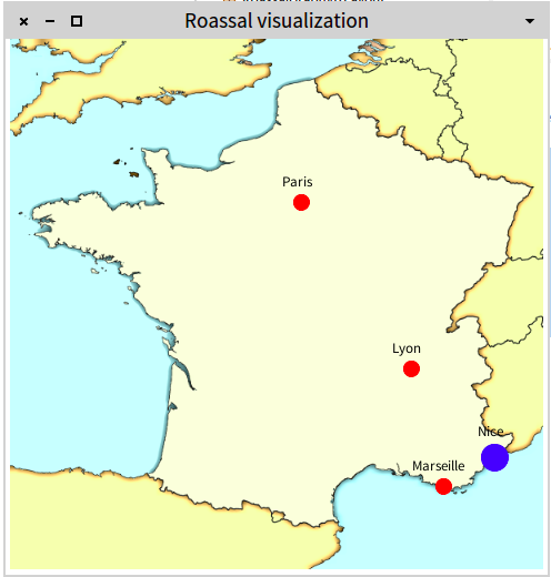
It should produce:
There is no reference to external files. It runs out of the box.
In case you got a sudden need to press a like button or do some retweet, here a bit of material:
https://www.facebook.com/media/set/?set=a.543459092407359.1073741830.3405434... https://twitter.com/objectprofile/status/401433558684008448
On our facebook account we have many more screenshots.
Cheers, Alexandre -- _,.;:~^~:;._,.;:~^~:;._,.;:~^~:;._,.;:~^~:;._,.;: Alexandre Bergel http://www.bergel.eu ^~:;._,.;:~^~:;._,.;:~^~:;._,.;:~^~:;._,.;:~^~:;.
-- www.tudorgirba.com "Every thing has its own flow"
Yes we do :) more will come in a couple of days Alexandre
Le 15-11-2013 à 18:02, Tudor Girba <tudor@tudorgirba.com> a écrit :
Nice!
Did you consider drawing the background map vectorially?
Cheers, Doru
On Fri, Nov 15, 2013 at 8:56 PM, Alexandre Bergel <alexandre.bergel@me.com> wrote: Hi!
During our pair coding session on Friday, we worked on a new builder for Roassal.
Here is short example:
| builder | builder := ROFranceMapBuilder new. builder shape circle size: 15; color: Color red; withLabel. builder showCities: #('Paris' 'Lyon' 'Marseille').
builder shape circle size: 25; color: Color blue; withLabel. builder show: 'Nice'.
builder open
It should produce: <Screen Shot 2013-11-15 at 4.53.30 PM.png>
There is no reference to external files. It runs out of the box.
In case you got a sudden need to press a like button or do some retweet, here a bit of material:
https://www.facebook.com/media/set/?set=a.543459092407359.1073741830.3405434... https://twitter.com/objectprofile/status/401433558684008448
On our facebook account we have many more screenshots.
Cheers, Alexandre -- _,.;:~^~:;._,.;:~^~:;._,.;:~^~:;._,.;:~^~:;._,.;: Alexandre Bergel http://www.bergel.eu ^~:;._,.;:~^~:;._,.;:~^~:;._,.;:~^~:;._,.;:~^~:;.
-- www.tudorgirba.com
"Every thing has its own flow"
I saw your other question :). I am looking forward to the result, Doru On Fri, Nov 15, 2013 at 10:32 PM, Alexandre Bergel <alexandre.bergel@me.com>wrote:
Yes we do :) more will come in a couple of days
Alexandre
Le 15-11-2013 à 18:02, Tudor Girba <tudor@tudorgirba.com> a écrit :
Nice!
Did you consider drawing the background map vectorially?
Cheers, Doru
On Fri, Nov 15, 2013 at 8:56 PM, Alexandre Bergel <alexandre.bergel@me.com
wrote:
Hi!
During our pair coding session on Friday, we worked on a new builder for Roassal.
Here is short example:
| builder | builder := ROFranceMapBuilder new. builder shape circle size: 15; color: Color red; withLabel. builder showCities: #('Paris' 'Lyon' 'Marseille').
builder shape circle size: 25; color: Color blue; withLabel. builder show: 'Nice'.
builder open
It should produce: <Screen Shot 2013-11-15 at 4.53.30 PM.png>
There is no reference to external files. It runs out of the box.
In case you got a sudden need to press a like button or do some retweet, here a bit of material:
https://www.facebook.com/media/set/?set=a.543459092407359.1073741830.3405434... https://twitter.com/objectprofile/status/401433558684008448
On our facebook account we have many more screenshots.
Cheers, Alexandre -- _,.;:~^~:;._,.;:~^~:;._,.;:~^~:;._,.;:~^~:;._,.;: Alexandre Bergel http://www.bergel.eu ^~:;._,.;:~^~:;._,.;:~^~:;._,.;:~^~:;._,.;:~^~:;.
-- www.tudorgirba.com
"Every thing has its own flow"
-- www.tudorgirba.com "Every thing has its own flow"
alexandre Check openstreetmap because I would love to have an openStreet map component in Pharo using Athens :) There is one topics about it in http://topics.pharo.org Stef
Yes we do :) more will come in a couple of days
Alexandre
Le 15-11-2013 à 18:02, Tudor Girba <tudor@tudorgirba.com> a écrit :
Nice!
Did you consider drawing the background map vectorially?
Cheers, Doru
On Fri, Nov 15, 2013 at 8:56 PM, Alexandre Bergel <alexandre.bergel@me.com> wrote: Hi!
During our pair coding session on Friday, we worked on a new builder for Roassal.
Here is short example:
| builder | builder := ROFranceMapBuilder new. builder shape circle size: 15; color: Color red; withLabel. builder showCities: #('Paris' 'Lyon' 'Marseille').
builder shape circle size: 25; color: Color blue; withLabel. builder show: 'Nice'.
builder open
It should produce: <Screen Shot 2013-11-15 at 4.53.30 PM.png>
There is no reference to external files. It runs out of the box.
In case you got a sudden need to press a like button or do some retweet, here a bit of material:
https://www.facebook.com/media/set/?set=a.543459092407359.1073741830.3405434... https://twitter.com/objectprofile/status/401433558684008448
On our facebook account we have many more screenshots.
Cheers, Alexandre -- _,.;:~^~:;._,.;:~^~:;._,.;:~^~:;._,.;:~^~:;._,.;: Alexandre Bergel http://www.bergel.eu ^~:;._,.;:~^~:;._,.;:~^~:;._,.;:~^~:;._,.;:~^~:;.
-- www.tudorgirba.com
"Every thing has its own flow"

Am 16.11.2013 um 18:11 schrieb Stéphane Ducasse <stephane.ducasse@inria.fr>:
alexandre
Check openstreetmap because I would love to have an openStreet map component in Pharo using Athens :)
+1 Norbert
There is one topics about it in http://topics.pharo.org
Stef
Yes we do :) more will come in a couple of days
Alexandre
Le 15-11-2013 à 18:02, Tudor Girba <tudor@tudorgirba.com> a écrit :
Nice!
Did you consider drawing the background map vectorially?
Cheers, Doru
On Fri, Nov 15, 2013 at 8:56 PM, Alexandre Bergel <alexandre.bergel@me.com> wrote: Hi!
During our pair coding session on Friday, we worked on a new builder for Roassal.
Here is short example:
| builder | builder := ROFranceMapBuilder new. builder shape circle size: 15; color: Color red; withLabel. builder showCities: #('Paris' 'Lyon' 'Marseille').
builder shape circle size: 25; color: Color blue; withLabel. builder show: 'Nice'.
builder open
It should produce: <Screen Shot 2013-11-15 at 4.53.30 PM.png>
There is no reference to external files. It runs out of the box.
In case you got a sudden need to press a like button or do some retweet, here a bit of material:
https://www.facebook.com/media/set/?set=a.543459092407359.1073741830.3405434... https://twitter.com/objectprofile/status/401433558684008448
On our facebook account we have many more screenshots.
Cheers, Alexandre -- _,.;:~^~:;._,.;:~^~:;._,.;:~^~:;._,.;:~^~:;._,.;: Alexandre Bergel http://www.bergel.eu ^~:;._,.;:~^~:;._,.;:~^~:;._,.;:~^~:;._,.;:~^~:;.
-- www.tudorgirba.com
"Every thing has its own flow"

Very nice, Alex, I guess you are using shape files then ? Sven On 15 Nov 2013, at 20:56, Alexandre Bergel <alexandre.bergel@me.com> wrote:
Hi!
During our pair coding session on Friday, we worked on a new builder for Roassal.
Here is short example:
| builder | builder := ROFranceMapBuilder new. builder shape circle size: 15; color: Color red; withLabel. builder showCities: #('Paris' 'Lyon' 'Marseille').
builder shape circle size: 25; color: Color blue; withLabel. builder show: 'Nice'.
builder open
It should produce: <Screen Shot 2013-11-15 at 4.53.30 PM.png>
There is no reference to external files. It runs out of the box.
In case you got a sudden need to press a like button or do some retweet, here a bit of material:
https://www.facebook.com/media/set/?set=a.543459092407359.1073741830.3405434... https://twitter.com/objectprofile/status/401433558684008448
On our facebook account we have many more screenshots.
Cheers, Alexandre -- _,.;:~^~:;._,.;:~^~:;._,.;:~^~:;._,.;:~^~:;._,.;: Alexandre Bergel http://www.bergel.eu ^~:;._,.;:~^~:;._,.;:~^~:;._,.;:~^~:;._,.;:~^~:;.
It is currently ad-hoc since we use a bitmap for the map, and locate cities with distances in pixels. We have found description in SVG and found a couple of formulas to map longitude and latitude into pixels. So we will have something vectorial very soon. If someone has some ideas, data, examples the we will be very happy to take them as challenges! Alexandre
Le 15-11-2013 à 18:39, Sven Van Caekenberghe <sven@stfx.eu> a écrit :
Very nice, Alex, I guess you are using shape files then ?
Sven
On 15 Nov 2013, at 20:56, Alexandre Bergel <alexandre.bergel@me.com> wrote:
Hi!
During our pair coding session on Friday, we worked on a new builder for Roassal.
Here is short example:
| builder | builder := ROFranceMapBuilder new. builder shape circle size: 15; color: Color red; withLabel. builder showCities: #('Paris' 'Lyon' 'Marseille').
builder shape circle size: 25; color: Color blue; withLabel. builder show: 'Nice'.
builder open
It should produce: <Screen Shot 2013-11-15 at 4.53.30 PM.png>
There is no reference to external files. It runs out of the box.
In case you got a sudden need to press a like button or do some retweet, here a bit of material:
https://www.facebook.com/media/set/?set=a.543459092407359.1073741830.3405434... https://twitter.com/objectprofile/status/401433558684008448
On our facebook account we have many more screenshots.
Cheers, Alexandre -- _,.;:~^~:;._,.;:~^~:;._,.;:~^~:;._,.;:~^~:;._,.;: Alexandre Bergel http://www.bergel.eu ^~:;._,.;:~^~:;._,.;:~^~:;._,.;:~^~:;._,.;:~^~:;.

Hi Alex, Have you checked Shapes to load ESRI .shp files? http://www.smalltalkhub.com/#!/~hernan/Shapes There are free shapefile maps in sites like this http://www.statsilk.com/maps/download-free-shapefile-maps Hernán El 16/11/2013 7:52, Alexandre Bergel escribió:
It is currently ad-hoc since we use a bitmap for the map, and locate cities with distances in pixels.
We have found description in SVG and found a couple of formulas to map longitude and latitude into pixels. So we will have something vectorial very soon.
If someone has some ideas, data, examples the we will be very happy to take them as challenges!
Alexandre
Le 15-11-2013 à 18:39, Sven Van Caekenberghe <sven@stfx.eu> a écrit :
Very nice, Alex, I guess you are using shape files then ?
Sven
On 15 Nov 2013, at 20:56, Alexandre Bergel <alexandre.bergel@me.com> wrote:
Hi!
During our pair coding session on Friday, we worked on a new builder for Roassal.
Here is short example:
| builder | builder := ROFranceMapBuilder new. builder shape circle size: 15; color: Color red; withLabel. builder showCities: #('Paris' 'Lyon' 'Marseille').
builder shape circle size: 25; color: Color blue; withLabel. builder show: 'Nice'.
builder open
It should produce: <Screen Shot 2013-11-15 at 4.53.30 PM.png>
There is no reference to external files. It runs out of the box.
In case you got a sudden need to press a like button or do some retweet, here a bit of material:
https://www.facebook.com/media/set/?set=a.543459092407359.1073741830.3405434... https://twitter.com/objectprofile/status/401433558684008448
On our facebook account we have many more screenshots.
Cheers, Alexandre -- _,.;:~^~:;._,.;:~^~:;._,.;:~^~:;._,.;:~^~:;._,.;: Alexandre Bergel http://www.bergel.eu ^~:;._,.;:~^~:;._,.;:~^~:;._,.;:~^~:;._,.;:~^~:;.
.
Have you checked Shapes to load ESRI .shp files?
Apparently it does not load in Pharo 3.0. I am not sure how popular are .shp files. The map I used in my examples are SVG path description. Our next goal is to represent GPS coordinate and cities. We will then probably try to show some visually interesting data (e.g., flights, tweets). Having this run at the top of Roassal @ Amber will come for free. Stay tuned! Also, in december, when I will visit inria @ Lille, I would like to push Athens more into Roassal.
There are free shapefile maps in sites like this
Impressive website. Cheers, Alexandre
El 16/11/2013 7:52, Alexandre Bergel escribió:
It is currently ad-hoc since we use a bitmap for the map, and locate cities with distances in pixels.
We have found description in SVG and found a couple of formulas to map longitude and latitude into pixels. So we will have something vectorial very soon.
If someone has some ideas, data, examples the we will be very happy to take them as challenges!
Alexandre
Le 15-11-2013 à 18:39, Sven Van Caekenberghe <sven@stfx.eu> a écrit :
Very nice, Alex, I guess you are using shape files then ?
Sven
On 15 Nov 2013, at 20:56, Alexandre Bergel <alexandre.bergel@me.com> wrote:
Hi!
During our pair coding session on Friday, we worked on a new builder for Roassal.
Here is short example:
| builder | builder := ROFranceMapBuilder new. builder shape circle size: 15; color: Color red; withLabel. builder showCities: #('Paris' 'Lyon' 'Marseille').
builder shape circle size: 25; color: Color blue; withLabel. builder show: 'Nice'.
builder open
It should produce: <Screen Shot 2013-11-15 at 4.53.30 PM.png>
There is no reference to external files. It runs out of the box.
In case you got a sudden need to press a like button or do some retweet, here a bit of material:
https://www.facebook.com/media/set/?set=a.543459092407359.1073741830.3405434... https://twitter.com/objectprofile/status/401433558684008448
On our facebook account we have many more screenshots.
Cheers, Alexandre -- _,.;:~^~:;._,.;:~^~:;._,.;:~^~:;._,.;:~^~:;._,.;: Alexandre Bergel http://www.bergel.eu ^~:;._,.;:~^~:;._,.;:~^~:;._,.;:~^~:;._,.;:~^~:;.
.
-- _,.;:~^~:;._,.;:~^~:;._,.;:~^~:;._,.;:~^~:;._,.;: Alexandre Bergel http://www.bergel.eu ^~:;._,.;:~^~:;._,.;:~^~:;._,.;:~^~:;._,.;:~^~:;.

Ok, thanks, I did not know Cheers Alexandre
Le 16-11-2013 à 22:31, btc@openinworld.com a écrit :
Alexandre Bergel wrote:
Have you checked Shapes to load ESRI .shp files?
Apparently it does not load in Pharo 3.0. I am not sure how popular are .shp files. The map I used in my examples are SVG path description.
SHaPe files a very popular with mining & oil companies => potential clients with big wallets. ESRI are the defacto standard for GIS. There are also probably a lot of smaller organisations limping by with data locked in old ESRI versions because upgrading is too expensive. Might be a good collaboration with your local GIS group.
cheers -ben
Our next goal is to represent GPS coordinate and cities. We will then probably try to show some visually interesting data (e.g., flights, tweets). Having this run at the top of Roassal @ Amber will come for free. Stay tuned!
Also, in december, when I will visit inria @ Lille, I would like to push Athens more into Roassal.
There are free shapefile maps in sites like this
Impressive website.
Cheers, Alexandre
El 16/11/2013 7:52, Alexandre Bergel escribió:
It is currently ad-hoc since we use a bitmap for the map, and locate cities with distances in pixels.
We have found description in SVG and found a couple of formulas to map longitude and latitude into pixels. So we will have something vectorial very soon.
If someone has some ideas, data, examples the we will be very happy to take them as challenges!
Alexandre
Le 15-11-2013 à 18:39, Sven Van Caekenberghe <sven@stfx.eu> a écrit :
Very nice, Alex, I guess you are using shape files then ?
Sven
On 15 Nov 2013, at 20:56, Alexandre Bergel <alexandre.bergel@me.com> wrote:
Hi!
During our pair coding session on Friday, we worked on a new builder for Roassal.
Here is short example:
| builder | builder := ROFranceMapBuilder new. builder shape circle size: 15; color: Color red; withLabel. builder showCities: #('Paris' 'Lyon' 'Marseille').
builder shape circle size: 25; color: Color blue; withLabel. builder show: 'Nice'.
builder open
It should produce: <Screen Shot 2013-11-15 at 4.53.30 PM.png>
There is no reference to external files. It runs out of the box.
In case you got a sudden need to press a like button or do some retweet, here a bit of material:
https://www.facebook.com/media/set/?set=a.543459092407359.1073741830.3405434... https://twitter.com/objectprofile/status/401433558684008448
On our facebook account we have many more screenshots.
Cheers, Alexandre -- _,.;:~^~:;._,.;:~^~:;._,.;:~^~:;._,.;:~^~:;._,.;: Alexandre Bergel http://www.bergel.eu ^~:;._,.;:~^~:;._,.;:~^~:;._,.;:~^~:;._,.;:~^~:;.
.
Yes, loading .shp is mandatory for GIS features. I don't know how it matches with your GPS project or it's complementary with your Athens/Roassal implementation. I hope so because it would be a real open door for GIS developers. I have updated the packages and added an install script. Try it tomorrow in Pharo 2.0 (for some reason I cannot upload changes in StHub now): http://www.smalltalkhub.com/#!/~hernan/Shapes With this dataset: https://drive.google.com/file/d/0B7XMfmjGRcXAdkgzeE84c2JtZEk/edit?usp=sharin... | shpE legend | shpE := ShapeEnsemble fromFile: 'ne_110m_admin_0_countries.shp'. shpE attribute: 'CONTINENT'. legend := ColorLegend mapValuesToRandom: shpE valuesOfCurrentAttribute. shpE legend: legend. shpE displayMorphic I have reviewed the code and there is a great effort put into. However there are places which need savage refactoring. Hernán El 16/11/2013 22:31, btc@openinworld.com escribió:
Alexandre Bergel wrote:
Have you checked Shapes to load ESRI .shp files?
Apparently it does not load in Pharo 3.0. I am not sure how popular are .shp files. The map I used in my examples are SVG path description.
SHaPe files a very popular with mining & oil companies => potential clients with big wallets. ESRI are the defacto standard for GIS. There are also probably a lot of smaller organisations limping by with data locked in old ESRI versions because upgrading is too expensive. Might be a good collaboration with your local GIS group.
cheers -ben
Our next goal is to represent GPS coordinate and cities. We will then probably try to show some visually interesting data (e.g., flights, tweets). Having this run at the top of Roassal @ Amber will come for free. Stay tuned!
Also, in december, when I will visit inria @ Lille, I would like to push Athens more into Roassal.
There are free shapefile maps in sites like this
Impressive website.
Cheers, Alexandre
El 16/11/2013 7:52, Alexandre Bergel escribió:
It is currently ad-hoc since we use a bitmap for the map, and locate cities with distances in pixels.
We have found description in SVG and found a couple of formulas to map longitude and latitude into pixels. So we will have something vectorial very soon.
If someone has some ideas, data, examples the we will be very happy to take them as challenges!
Alexandre
Le 15-11-2013 à 18:39, Sven Van Caekenberghe<sven@stfx.eu> a écrit :
Very nice, Alex, I guess you are using shape files then ?
Sven
On 15 Nov 2013, at 20:56, Alexandre Bergel<alexandre.bergel@me.com> wrote:
Hi!
During our pair coding session on Friday, we worked on a new builder for Roassal.
Here is short example:
| builder | builder := ROFranceMapBuilder new. builder shape circle size: 15; color: Color red; withLabel. builder showCities: #('Paris' 'Lyon' 'Marseille').
builder shape circle size: 25; color: Color blue; withLabel. builder show: 'Nice'.
builder open
It should produce: <Screen Shot 2013-11-15 at 4.53.30 PM.png>
There is no reference to external files. It runs out of the box.
In case you got a sudden need to press a like button or do some retweet, here a bit of material:
https://www.facebook.com/media/set/?set=a.543459092407359.1073741830.3405434... https://twitter.com/objectprofile/status/401433558684008448
On our facebook account we have many more screenshots.
Cheers, Alexandre -- _,.;:~^~:;._,.;:~^~:;._,.;:~^~:;._,.;:~^~:;._,.;: Alexandre Bergelhttp://www.bergel.eu ^~:;._,.;:~^~:;._,.;:~^~:;._,.;:~^~:;._,.;:~^~:;.
.
We indeed may have a need in the future about shp files. We will see. Alexandre On Nov 17, 2013, at 2:40 AM, Hernán Morales Durand <hernan.morales@gmail.com> wrote:
Yes, loading .shp is mandatory for GIS features. I don't know how it matches with your GPS project or it's complementary with your Athens/Roassal implementation. I hope so because it would be a real open door for GIS developers.
I have updated the packages and added an install script. Try it tomorrow in Pharo 2.0 (for some reason I cannot upload changes in StHub now):
http://www.smalltalkhub.com/#!/~hernan/Shapes
With this dataset:
https://drive.google.com/file/d/0B7XMfmjGRcXAdkgzeE84c2JtZEk/edit?usp=sharin...
| shpE legend | shpE := ShapeEnsemble fromFile: 'ne_110m_admin_0_countries.shp'. shpE attribute: 'CONTINENT'. legend := ColorLegend mapValuesToRandom: shpE valuesOfCurrentAttribute. shpE legend: legend. shpE displayMorphic
I have reviewed the code and there is a great effort put into. However there are places which need savage refactoring.
Hernán
El 16/11/2013 22:31, btc@openinworld.com escribió:
Alexandre Bergel wrote:
Have you checked Shapes to load ESRI .shp files?
Apparently it does not load in Pharo 3.0. I am not sure how popular are .shp files. The map I used in my examples are SVG path description.
SHaPe files a very popular with mining & oil companies => potential clients with big wallets. ESRI are the defacto standard for GIS. There are also probably a lot of smaller organisations limping by with data locked in old ESRI versions because upgrading is too expensive. Might be a good collaboration with your local GIS group.
cheers -ben
Our next goal is to represent GPS coordinate and cities. We will then probably try to show some visually interesting data (e.g., flights, tweets). Having this run at the top of Roassal @ Amber will come for free. Stay tuned!
Also, in december, when I will visit inria @ Lille, I would like to push Athens more into Roassal.
There are free shapefile maps in sites like this
Impressive website.
Cheers, Alexandre
El 16/11/2013 7:52, Alexandre Bergel escribió:
It is currently ad-hoc since we use a bitmap for the map, and locate cities with distances in pixels.
We have found description in SVG and found a couple of formulas to map longitude and latitude into pixels. So we will have something vectorial very soon.
If someone has some ideas, data, examples the we will be very happy to take them as challenges!
Alexandre
Le 15-11-2013 à 18:39, Sven Van Caekenberghe<sven@stfx.eu> a écrit :
Very nice, Alex, I guess you are using shape files then ?
Sven
On 15 Nov 2013, at 20:56, Alexandre Bergel<alexandre.bergel@me.com> wrote:
Hi!
During our pair coding session on Friday, we worked on a new builder for Roassal.
Here is short example:
| builder | builder := ROFranceMapBuilder new. builder shape circle size: 15; color: Color red; withLabel. builder showCities: #('Paris' 'Lyon' 'Marseille').
builder shape circle size: 25; color: Color blue; withLabel. builder show: 'Nice'.
builder open
It should produce: <Screen Shot 2013-11-15 at 4.53.30 PM.png>
There is no reference to external files. It runs out of the box.
In case you got a sudden need to press a like button or do some retweet, here a bit of material:
https://www.facebook.com/media/set/?set=a.543459092407359.1073741830.3405434... https://twitter.com/objectprofile/status/401433558684008448
On our facebook account we have many more screenshots.
Cheers, Alexandre -- _,.;:~^~:;._,.;:~^~:;._,.;:~^~:;._,.;:~^~:;._,.;: Alexandre Bergelhttp://www.bergel.eu ^~:;._,.;:~^~:;._,.;:~^~:;._,.;:~^~:;._,.;:~^~:;.
.
-- _,.;:~^~:;._,.;:~^~:;._,.;:~^~:;._,.;:~^~:;._,.;: Alexandre Bergel http://www.bergel.eu ^~:;._,.;:~^~:;._,.;:~^~:;._,.;:~^~:;._,.;:~^~:;.

There is open data published as Shape files. http://opendata.awt.be/organization/dgo1-routes-et-batiments On Sun, Nov 17, 2013 at 7:47 PM, Alexandre Bergel <alexandre.bergel@me.com>wrote:
We indeed may have a need in the future about shp files. We will see.
Alexandre
On Nov 17, 2013, at 2:40 AM, Hernán Morales Durand < hernan.morales@gmail.com> wrote:
Yes, loading .shp is mandatory for GIS features. I don't know how it matches with your GPS project or it's complementary with your Athens/Roassal implementation. I hope so because it would be a real open door for GIS developers.
I have updated the packages and added an install script. Try it tomorrow in Pharo 2.0 (for some reason I cannot upload changes in StHub now):
http://www.smalltalkhub.com/#!/~hernan/Shapes
With this dataset:
https://drive.google.com/file/d/0B7XMfmjGRcXAdkgzeE84c2JtZEk/edit?usp=sharin...
| shpE legend | shpE := ShapeEnsemble fromFile: 'ne_110m_admin_0_countries.shp'. shpE attribute: 'CONTINENT'. legend := ColorLegend mapValuesToRandom: shpE valuesOfCurrentAttribute. shpE legend: legend. shpE displayMorphic
I have reviewed the code and there is a great effort put into. However
there are places which need savage refactoring.
Hernán
El 16/11/2013 22:31, btc@openinworld.com escribió:
Alexandre Bergel wrote:
Have you checked Shapes to load ESRI .shp files?
Apparently it does not load in Pharo 3.0. I am not sure how popular
are .shp files. The map I used in my examples are SVG path description.
SHaPe files a very popular with mining & oil companies => potential clients with big wallets. ESRI are the defacto standard for GIS. There are also probably a lot of smaller organisations limping by with data locked in old ESRI versions because upgrading is too expensive. Might be a good collaboration with your local GIS group.
cheers -ben
Our next goal is to represent GPS coordinate and cities. We will then probably try to show some visually interesting data (e.g., flights, tweets). Having this run at the top of Roassal @ Amber will come for free. Stay tuned!
Also, in december, when I will visit inria @ Lille, I would like to push Athens more into Roassal.
There are free shapefile maps in sites like this
Impressive website.
Cheers, Alexandre
El 16/11/2013 7:52, Alexandre Bergel escribió:
It is currently ad-hoc since we use a bitmap for the map, and locate cities with distances in pixels.
We have found description in SVG and found a couple of formulas to map longitude and latitude into pixels. So we will have something vectorial very soon.
If someone has some ideas, data, examples the we will be very happy to take them as challenges!
Alexandre
Le 15-11-2013 à 18:39, Sven Van Caekenberghe<sven@stfx.eu> a écrit :
Very nice, Alex, I guess you are using shape files then ?
Sven
On 15 Nov 2013, at 20:56, Alexandre Bergel<alexandre.bergel@me.com> wrote:
Hi!
During our pair coding session on Friday, we worked on a new builder for Roassal.
Here is short example:
| builder | builder := ROFranceMapBuilder new. builder shape circle size: 15; color: Color red; withLabel. builder showCities: #('Paris' 'Lyon' 'Marseille').
builder shape circle size: 25; color: Color blue; withLabel. builder show: 'Nice'.
builder open
It should produce: <Screen Shot 2013-11-15 at 4.53.30 PM.png>
There is no reference to external files. It runs out of the box.
In case you got a sudden need to press a like button or do some retweet, here a bit of material:
https://www.facebook.com/media/set/?set=a.543459092407359.1073741830.3405434...
https://twitter.com/objectprofile/status/401433558684008448
On our facebook account we have many more screenshots.
Cheers, Alexandre -- _,.;:~^~:;._,.;:~^~:;._,.;:~^~:;._,.;:~^~:;._,.;: Alexandre Bergelhttp://www.bergel.eu ^~:;._,.;:~^~:;._,.;:~^~:;._,.;:~^~:;._,.;:~^~:;.
.
-- _,.;:~^~:;._,.;:~^~:;._,.;:~^~:;._,.;:~^~:;._,.;: Alexandre Bergel http://www.bergel.eu ^~:;._,.;:~^~:;._,.;:~^~:;._,.;:~^~:;._,.;:~^~:;.
hernan is shp a binary format? Stef On Nov 16, 2013, at 9:43 PM, Hernán Morales Durand <hernan.morales@gmail.com> wrote:
Hi Alex, Have you checked Shapes to load ESRI .shp files?
http://www.smalltalkhub.com/#!/~hernan/Shapes
There are free shapefile maps in sites like this
http://www.statsilk.com/maps/download-free-shapefile-maps
Hernán
El 16/11/2013 7:52, Alexandre Bergel escribió:
It is currently ad-hoc since we use a bitmap for the map, and locate cities with distances in pixels.
We have found description in SVG and found a couple of formulas to map longitude and latitude into pixels. So we will have something vectorial very soon.
If someone has some ideas, data, examples the we will be very happy to take them as challenges!
Alexandre
Le 15-11-2013 à 18:39, Sven Van Caekenberghe <sven@stfx.eu> a écrit :
Very nice, Alex, I guess you are using shape files then ?
Sven
On 15 Nov 2013, at 20:56, Alexandre Bergel <alexandre.bergel@me.com> wrote:
Hi!
During our pair coding session on Friday, we worked on a new builder for Roassal.
Here is short example:
| builder | builder := ROFranceMapBuilder new. builder shape circle size: 15; color: Color red; withLabel. builder showCities: #('Paris' 'Lyon' 'Marseille').
builder shape circle size: 25; color: Color blue; withLabel. builder show: 'Nice'.
builder open
It should produce: <Screen Shot 2013-11-15 at 4.53.30 PM.png>
There is no reference to external files. It runs out of the box.
In case you got a sudden need to press a like button or do some retweet, here a bit of material:
https://www.facebook.com/media/set/?set=a.543459092407359.1073741830.3405434... https://twitter.com/objectprofile/status/401433558684008448
On our facebook account we have many more screenshots.
Cheers, Alexandre -- _,.;:~^~:;._,.;:~^~:;._,.;:~^~:;._,.;:~^~:;._,.;: Alexandre Bergel http://www.bergel.eu ^~:;._,.;:~^~:;._,.;:~^~:;._,.;:~^~:;._,.;:~^~:;.
.

https://en.wikipedia.org/wiki/Shapefile On Sun, Nov 17, 2013 at 6:02 PM, Stéphane Ducasse <stephane.ducasse@inria.fr> wrote:
hernan
is shp a binary format?
Stef On Nov 16, 2013, at 9:43 PM, Hernán Morales Durand <hernan.morales@gmail.com> wrote:
Hi Alex, Have you checked Shapes to load ESRI .shp files?
http://www.smalltalkhub.com/#!/~hernan/Shapes
There are free shapefile maps in sites like this
http://www.statsilk.com/maps/download-free-shapefile-maps
Hernán
El 16/11/2013 7:52, Alexandre Bergel escribió:
It is currently ad-hoc since we use a bitmap for the map, and locate cities with distances in pixels.
We have found description in SVG and found a couple of formulas to map longitude and latitude into pixels. So we will have something vectorial very soon.
If someone has some ideas, data, examples the we will be very happy to take them as challenges!
Alexandre
Le 15-11-2013 à 18:39, Sven Van Caekenberghe <sven@stfx.eu> a écrit :
Very nice, Alex, I guess you are using shape files then ?
Sven
On 15 Nov 2013, at 20:56, Alexandre Bergel <alexandre.bergel@me.com> wrote:
Hi!
During our pair coding session on Friday, we worked on a new builder for Roassal.
Here is short example:
| builder | builder := ROFranceMapBuilder new. builder shape circle size: 15; color: Color red; withLabel. builder showCities: #('Paris' 'Lyon' 'Marseille').
builder shape circle size: 25; color: Color blue; withLabel. builder show: 'Nice'.
builder open
It should produce: <Screen Shot 2013-11-15 at 4.53.30 PM.png>
There is no reference to external files. It runs out of the box.
In case you got a sudden need to press a like button or do some retweet, here a bit of material:
https://www.facebook.com/media/set/?set=a.543459092407359.1073741830.3405434... https://twitter.com/objectprofile/status/401433558684008448
On our facebook account we have many more screenshots.
Cheers, Alexandre -- _,.;:~^~:;._,.;:~^~:;._,.;:~^~:;._,.;:~^~:;._,.;: Alexandre Bergel http://www.bergel.eu ^~:;._,.;:~^~:;._,.;:~^~:;._,.;:~^~:;._,.;:~^~:;.
.
-- Serge Stinckwich UCBN & UMI UMMISCO 209 (IRD/UPMC) Every DSL ends up being Smalltalk http://www.doesnotunderstand.org/
tx serge :) On Nov 17, 2013, at 6:06 PM, Serge Stinckwich <serge.stinckwich@gmail.com> wrote:
https://en.wikipedia.org/wiki/Shapefile
On Sun, Nov 17, 2013 at 6:02 PM, Stéphane Ducasse <stephane.ducasse@inria.fr> wrote:
hernan
is shp a binary format?
Stef On Nov 16, 2013, at 9:43 PM, Hernán Morales Durand <hernan.morales@gmail.com> wrote:
Hi Alex, Have you checked Shapes to load ESRI .shp files?
http://www.smalltalkhub.com/#!/~hernan/Shapes
There are free shapefile maps in sites like this
http://www.statsilk.com/maps/download-free-shapefile-maps
Hernán
El 16/11/2013 7:52, Alexandre Bergel escribió:
It is currently ad-hoc since we use a bitmap for the map, and locate cities with distances in pixels.
We have found description in SVG and found a couple of formulas to map longitude and latitude into pixels. So we will have something vectorial very soon.
If someone has some ideas, data, examples the we will be very happy to take them as challenges!
Alexandre
Le 15-11-2013 à 18:39, Sven Van Caekenberghe <sven@stfx.eu> a écrit :
Very nice, Alex, I guess you are using shape files then ?
Sven
On 15 Nov 2013, at 20:56, Alexandre Bergel <alexandre.bergel@me.com> wrote:
Hi!
During our pair coding session on Friday, we worked on a new builder for Roassal.
Here is short example:
| builder | builder := ROFranceMapBuilder new. builder shape circle size: 15; color: Color red; withLabel. builder showCities: #('Paris' 'Lyon' 'Marseille').
builder shape circle size: 25; color: Color blue; withLabel. builder show: 'Nice'.
builder open
It should produce: <Screen Shot 2013-11-15 at 4.53.30 PM.png>
There is no reference to external files. It runs out of the box.
In case you got a sudden need to press a like button or do some retweet, here a bit of material:
https://www.facebook.com/media/set/?set=a.543459092407359.1073741830.3405434... https://twitter.com/objectprofile/status/401433558684008448
On our facebook account we have many more screenshots.
Cheers, Alexandre -- _,.;:~^~:;._,.;:~^~:;._,.;:~^~:;._,.;:~^~:;._,.;: Alexandre Bergel http://www.bergel.eu ^~:;._,.;:~^~:;._,.;:~^~:;._,.;:~^~:;._,.;:~^~:;.
.
-- Serge Stinckwich UCBN & UMI UMMISCO 209 (IRD/UPMC) Every DSL ends up being Smalltalk http://www.doesnotunderstand.org/

This is cool! :-) Jura El 15-11-2013, a las 16:56, Alexandre Bergel <alexandre.bergel@me.com> escribió:
Hi!
During our pair coding session on Friday, we worked on a new builder for Roassal.
Here is short example:
| builder | builder := ROFranceMapBuilder new. builder shape circle size: 15; color: Color red; withLabel. builder showCities: #('Paris' 'Lyon' 'Marseille').
builder shape circle size: 25; color: Color blue; withLabel. builder show: 'Nice'.
builder open
It should produce: <Screen Shot 2013-11-15 at 4.53.30 PM.png>
There is no reference to external files. It runs out of the box.
In case you got a sudden need to press a like button or do some retweet, here a bit of material:
https://www.facebook.com/media/set/?set=a.543459092407359.1073741830.3405434... https://twitter.com/objectprofile/status/401433558684008448
On our facebook account we have many more screenshots.
Cheers, Alexandre -- _,.;:~^~:;._,.;:~^~:;._,.;:~^~:;._,.;:~^~:;._,.;: Alexandre Bergel http://www.bergel.eu ^~:;._,.;:~^~:;._,.;:~^~:;._,.;:~^~:;._,.;:~^~:;.
participants (10)
-
 Alexandre Bergel
 -
 btc@openinworld.com
 -
 Hernán Morales Durand
 -
 Juraj Kubelka
 -
 Norbert Hartl
 -
 phil@highoctane.be
 -
 Serge Stinckwich
 -
 Stéphane Ducasse
 -
 Sven Van Caekenberghe
 -
 Tudor Girba