Territorial loading problems & alternative ways of loading data for making a choropleth map

Hi, I would like a choropleth map of Colombian departments [1]. The first approach would be to use Territorial, but loading it is not working on Pharo 6.1 (used on Manjaro Linux): It doesn't appears in the Catalog, Gopher load gives me: "XMLFileException: File does does not exist: /home/offray/Programas/Pharo/6.1a/Dev24/territorial_files/fao/fao_country_names.xml" and loading Monticello bleeding edge gives me "FileDoesNotExist: File @ /home/offray/Programas/Pharo/6.1a/Dev24/territorial_files/opengeocode/wc-ASCII.csv". There is another way to make such choropleth map? [1] https://en.wikipedia.org/wiki/Departments_of_Colombia Thanks, Offray

I am revieweing this right now. Lot of work in the bioinformatics department! Hernán 2017-10-23 22:59 GMT-03:00 Offray Vladimir Luna Cárdenas <offray.luna@mutabit.com>:
Hi,
I would like a choropleth map of Colombian departments [1]. The first approach would be to use Territorial, but loading it is not working on Pharo 6.1 (used on Manjaro Linux): It doesn't appears in the Catalog, Gopher load gives me: "XMLFileException: File does does not exist: /home/offray/Programas/Pharo/6.1a/Dev24/territorial_files/fao/fao_country_names.xml" and loading Monticello bleeding edge gives me "FileDoesNotExist: File @ /home/offray/Programas/Pharo/6.1a/Dev24/territorial_files/opengeocode/wc-ASCII.csv". There is another way to make such choropleth map?
[1] https://en.wikipedia.org/wiki/Departments_of_Colombia
Thanks,
Offray
Hi, Answering myself: I was able to fix this problem by downloading the "territorial_files" zip folder from the source repo and unzipping it to the image folder. After that Metacello bleeding edge (not Monticello, my mistake) installation worked properly. So, it seems that proper downloading and unzipping of supporting files is not working. I have found this also for the GADM files as reported in [1]. By the way, I have created a Grafoscopio notebook to take some interactive notes on my learning of Territorial [2][3]. My first impressions are that this is a pretty potent package, but still needs a more fluid installation and the supporting files are huge, and I wonder if there is any way to query/download the data on demand. [1] https://github.com/hernanmd/Territorial/issues/2. [2] http://mutabit.com/repos.fossil/grafoscopio/finfo?name=Docs/En/Books/Territo... [3] http://mutabit.com/repos.fossil/grafoscopio/doc/tip/Docs/En/Books/Territoria... Thanks and keep the good work, Offray On 23/10/17 20:59, Offray Vladimir Luna Cárdenas wrote:
Hi,
I would like a choropleth map of Colombian departments [1]. The first approach would be to use Territorial, but loading it is not working on Pharo 6.1 (used on Manjaro Linux): It doesn't appears in the Catalog, Gopher load gives me: "XMLFileException: File does does not exist: /home/offray/Programas/Pharo/6.1a/Dev24/territorial_files/fao/fao_country_names.xml" and loading Monticello bleeding edge gives me "FileDoesNotExist: File @ /home/offray/Programas/Pharo/6.1a/Dev24/territorial_files/opengeocode/wc-ASCII.csv". There is another way to make such choropleth map?
[1] https://en.wikipedia.org/wiki/Departments_of_Colombia
Thanks,
Offray
2017-10-24 0:01 GMT-03:00 Offray Vladimir Luna Cárdenas <offray.luna@mutabit.com>:
Hi,
Answering myself: I was able to fix this problem by downloading the "territorial_files" zip folder from the source repo and unzipping it to the image folder. After that Metacello bleeding edge (not Monticello, my mistake) installation worked properly. So, it seems that proper downloading and unzipping of supporting files is not working. I have found this also for the GADM files as reported in [1].
Tomorrow I will check in Linux.
By the way, I have created a Grafoscopio notebook to take some interactive notes on my learning of Territorial [2][3]. My first impressions are that this is a pretty potent package, but still needs a more fluid installation and the supporting files are huge, and I wonder if there is any way to query/download the data on demand.
Thank you for the feedback Offray. This is an issue I should profile because some data sets are huge, and then think about how to provide maybe a customized installation or download spcific resource on demand. Cheers, Hernán
[1] https://github.com/hernanmd/Territorial/issues/2. [2] http://mutabit.com/repos.fossil/grafoscopio/finfo?name=Docs/En/Books/Territo... [3] http://mutabit.com/repos.fossil/grafoscopio/doc/tip/Docs/En/Books/Territoria...
Thanks and keep the good work,
Offray
On 23/10/17 20:59, Offray Vladimir Luna Cárdenas wrote:
Hi,
I would like a choropleth map of Colombian departments [1]. The first approach would be to use Territorial, but loading it is not working on Pharo 6.1 (used on Manjaro Linux): It doesn't appears in the Catalog, Gopher load gives me: "XMLFileException: File does does not exist: /home/offray/Programas/Pharo/6.1a/Dev24/territorial_files/fao/fao_country_names.xml" and loading Monticello bleeding edge gives me "FileDoesNotExist: File @ /home/offray/Programas/Pharo/6.1a/Dev24/territorial_files/opengeocode/wc-ASCII.csv". There is another way to make such choropleth map?
[1] https://en.wikipedia.org/wiki/Departments_of_Colombia
Thanks,
Offray
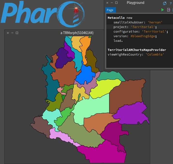
Hola Offray, I tried loading in Windows 8.1 and it loads fine using: Metacello new smalltalkhubUser: 'hernan' project: 'Territorial'; configuration: 'Territorial'; version: #bleedingEdge; load. Then load TerritorialData-AMCharts-HernanMoralesDurand.2 from the repository. I published some "fixes" related to Spec and Roassal. (I have to review them because I'm porting other packages to Pharo 6.1, but it should work for displaying maps). The following expression displays a window with Colombia departments: TerritorialAMChartsMapsProvider viewHighResCountry: 'Colombia' For a choropleth with a heatmap or centroids have a look at how I did it in PhyloclassTalk in SmalltalkHub, again I should update it to work in Pharo 6.1. Cheers, Hernán 2017-10-23 22:59 GMT-03:00 Offray Vladimir Luna Cárdenas <offray.luna@mutabit.com>:
Hi,
I would like a choropleth map of Colombian departments [1]. The first approach would be to use Territorial, but loading it is not working on Pharo 6.1 (used on Manjaro Linux): It doesn't appears in the Catalog, Gopher load gives me: "XMLFileException: File does does not exist: /home/offray/Programas/Pharo/6.1a/Dev24/territorial_files/fao/fao_country_names.xml" and loading Monticello bleeding edge gives me "FileDoesNotExist: File @ /home/offray/Programas/Pharo/6.1a/Dev24/territorial_files/opengeocode/wc-ASCII.csv". There is another way to make such choropleth map?
[1] https://en.wikipedia.org/wiki/Departments_of_Colombia
Thanks,
Offray
2017-10-24 1:21 GMT-03:00 Hernán Morales Durand <hernan.morales@gmail.com>:
Hola Offray,
I tried loading in Windows 8.1 and it loads fine using:
Metacello new smalltalkhubUser: 'hernan' project: 'Territorial'; configuration: 'Territorial'; version: #bleedingEdge; load.
Then load TerritorialData-AMCharts-HernanMoralesDurand.2 from the repository.
TerritorialData-AMCharts-HernanMoralesDurand.3 or the latest version you find :)
I published some "fixes" related to Spec and Roassal. (I have to review them because I'm porting other packages to Pharo 6.1, but it should work for displaying maps).
The following expression displays a window with Colombia departments:
TerritorialAMChartsMapsProvider viewHighResCountry: 'Colombia'
For a choropleth with a heatmap or centroids have a look at how I did it in PhyloclassTalk in SmalltalkHub, again I should update it to work in Pharo 6.1.
Cheers,
Hernán
2017-10-23 22:59 GMT-03:00 Offray Vladimir Luna Cárdenas <offray.luna@mutabit.com>:
Hi,
I would like a choropleth map of Colombian departments [1]. The first approach would be to use Territorial, but loading it is not working on Pharo 6.1 (used on Manjaro Linux): It doesn't appears in the Catalog, Gopher load gives me: "XMLFileException: File does does not exist: /home/offray/Programas/Pharo/6.1a/Dev24/territorial_files/fao/fao_country_names.xml" and loading Monticello bleeding edge gives me "FileDoesNotExist: File @ /home/offray/Programas/Pharo/6.1a/Dev24/territorial_files/opengeocode/wc-ASCII.csv". There is another way to make such choropleth map?
[1] https://en.wikipedia.org/wiki/Departments_of_Colombia
Thanks,
Offray
Gracias Hernán! This is working fine. I would like to put the displayed map inside the GT playground right panel, to get something similar to what you get when you execute "RTMapLocationExample new exampleSeismOnEarth" from a playground. Do you have any planned support for that? I could try to use some similar approach to the one I take on the Panama Papers choropleth map [1][2] to export some Territorial data for visualizations in a light format (120kb file example at: [3]), if you're interested. [1] http://mutabit.com/offray/blog/en/entry/panama-papers-1 [2] http://mutabit.com/repos.fossil/panama-papers/doc/tip/index.html [3] http://mutabit.com/repos.fossil/panama-papers/doc/tip/territories.ston Cheers, Offray On 23/10/17 23:21, Hernán Morales Durand wrote:
Hola Offray,
I tried loading in Windows 8.1 and it loads fine using:
Metacello new smalltalkhubUser: 'hernan' project: 'Territorial'; configuration: 'Territorial'; version: #bleedingEdge; load.
Then load TerritorialData-AMCharts-HernanMoralesDurand.2 from the repository.
I published some "fixes" related to Spec and Roassal. (I have to review them because I'm porting other packages to Pharo 6.1, but it should work for displaying maps).
The following expression displays a window with Colombia departments:
TerritorialAMChartsMapsProvider viewHighResCountry: 'Colombia'
For a choropleth with a heatmap or centroids have a look at how I did it in PhyloclassTalk in SmalltalkHub, again I should update it to work in Pharo 6.1.
Cheers,
Hernán
2017-10-23 22:59 GMT-03:00 Offray Vladimir Luna Cárdenas <offray.luna@mutabit.com>:
Hi,
I would like a choropleth map of Colombian departments [1]. The first approach would be to use Territorial, but loading it is not working on Pharo 6.1 (used on Manjaro Linux): It doesn't appears in the Catalog, Gopher load gives me: "XMLFileException: File does does not exist: /home/offray/Programas/Pharo/6.1a/Dev24/territorial_files/fao/fao_country_names.xml" and loading Monticello bleeding edge gives me "FileDoesNotExist: File @ /home/offray/Programas/Pharo/6.1a/Dev24/territorial_files/opengeocode/wc-ASCII.csv". There is another way to make such choropleth map?
[1] https://en.wikipedia.org/wiki/Departments_of_Colombia
Thanks,
Offray
2017-10-24 15:24 GMT-03:00 Offray Vladimir Luna Cárdenas <offray.luna@mutabit.com>:
Gracias Hernán!
No problema :)
This is working fine. I would like to put the displayed map inside the GT playground right panel, to get something similar to what you get when you execute "RTMapLocationExample new exampleSeismOnEarth" from a playground. Do you have any planned support for that?
I know this should be as easy as adding a <gtInspectorPresentationOrder: ... > pragma gtInspectorViewIn: composite <gtInspectorPresentationOrder: 60> composite morph title: 'Territorial Map'; display: [ view build ] but still I have to investigate how to connect a RTView or TRMorph with GT inspector
I could try to use some similar approach to the one I take on the Panama Papers choropleth map [1][2] to export some Territorial data for visualizations in a light format (120kb file example at: [3]), if you're interested.
[1] http://mutabit.com/offray/blog/en/entry/panama-papers-1 [2] http://mutabit.com/repos.fossil/panama-papers/doc/tip/index.html [3] http://mutabit.com/repos.fossil/panama-papers/doc/tip/territories.ston
Super! It would be nice to see usage in other scenarios! Let me know how it goes. Cheers, Hernán
Cheers,
Offray
On 23/10/17 23:21, Hernán Morales Durand wrote:
Hola Offray,
I tried loading in Windows 8.1 and it loads fine using:
Metacello new smalltalkhubUser: 'hernan' project: 'Territorial'; configuration: 'Territorial'; version: #bleedingEdge; load.
Then load TerritorialData-AMCharts-HernanMoralesDurand.2 from the repository.
I published some "fixes" related to Spec and Roassal. (I have to review them because I'm porting other packages to Pharo 6.1, but it should work for displaying maps).
The following expression displays a window with Colombia departments:
TerritorialAMChartsMapsProvider viewHighResCountry: 'Colombia'
For a choropleth with a heatmap or centroids have a look at how I did it in PhyloclassTalk in SmalltalkHub, again I should update it to work in Pharo 6.1.
Cheers,
Hernán
2017-10-23 22:59 GMT-03:00 Offray Vladimir Luna Cárdenas <offray.luna@mutabit.com>:
Hi,
I would like a choropleth map of Colombian departments [1]. The first approach would be to use Territorial, but loading it is not working on Pharo 6.1 (used on Manjaro Linux): It doesn't appears in the Catalog, Gopher load gives me: "XMLFileException: File does does not exist: /home/offray/Programas/Pharo/6.1a/Dev24/territorial_files/fao/fao_country_names.xml" and loading Monticello bleeding edge gives me "FileDoesNotExist: File @ /home/offray/Programas/Pharo/6.1a/Dev24/territorial_files/opengeocode/wc-ASCII.csv". There is another way to make such choropleth map?
[1] https://en.wikipedia.org/wiki/Departments_of_Colombia
Thanks,
Offray

You can directly use the Roassal presentation gtInspectorExtension: composite <gtInspectorPresentationOrder: 20> composite roassal2 title: â...' initializeView: [ YourViewOrBuilder ]; painting: [ :yourViewOrBuilder | ⦠] Doru
On Oct 25, 2017, at 5:57 AM, Hernán Morales Durand <hernan.morales@gmail.com> wrote:
2017-10-24 15:24 GMT-03:00 Offray Vladimir Luna Cárdenas <offray.luna@mutabit.com>:
Gracias Hernán!
No problema :)
This is working fine. I would like to put the displayed map inside the GT playground right panel, to get something similar to what you get when you execute "RTMapLocationExample new exampleSeismOnEarth" from a playground. Do you have any planned support for that?
I know this should be as easy as adding a <gtInspectorPresentationOrder: ... > pragma
gtInspectorViewIn: composite <gtInspectorPresentationOrder: 60>
composite morph title: 'Territorial Map'; display: [ view build ]
but still I have to investigate how to connect a RTView or TRMorph with GT inspector
I could try to use some similar approach to the one I take on the Panama Papers choropleth map [1][2] to export some Territorial data for visualizations in a light format (120kb file example at: [3]), if you're interested.
[1] http://mutabit.com/offray/blog/en/entry/panama-papers-1 [2] http://mutabit.com/repos.fossil/panama-papers/doc/tip/index.html [3] http://mutabit.com/repos.fossil/panama-papers/doc/tip/territories.ston
Super! It would be nice to see usage in other scenarios! Let me know how it goes.
Cheers,
Hernán
Cheers,
Offray
On 23/10/17 23:21, Hernán Morales Durand wrote:
Hola Offray,
I tried loading in Windows 8.1 and it loads fine using:
Metacello new smalltalkhubUser: 'hernan' project: 'Territorial'; configuration: 'Territorial'; version: #bleedingEdge; load.
Then load TerritorialData-AMCharts-HernanMoralesDurand.2 from the repository.
I published some "fixes" related to Spec and Roassal. (I have to review them because I'm porting other packages to Pharo 6.1, but it should work for displaying maps).
The following expression displays a window with Colombia departments:
TerritorialAMChartsMapsProvider viewHighResCountry: 'Colombia'
For a choropleth with a heatmap or centroids have a look at how I did it in PhyloclassTalk in SmalltalkHub, again I should update it to work in Pharo 6.1.
Cheers,
Hernán
2017-10-23 22:59 GMT-03:00 Offray Vladimir Luna Cárdenas <offray.luna@mutabit.com>:
Hi,
I would like a choropleth map of Colombian departments [1]. The first approach would be to use Territorial, but loading it is not working on Pharo 6.1 (used on Manjaro Linux): It doesn't appears in the Catalog, Gopher load gives me: "XMLFileException: File does does not exist: /home/offray/Programas/Pharo/6.1a/Dev24/territorial_files/fao/fao_country_names.xml" and loading Monticello bleeding edge gives me "FileDoesNotExist: File @ /home/offray/Programas/Pharo/6.1a/Dev24/territorial_files/opengeocode/wc-ASCII.csv". There is another way to make such choropleth map?
[1] https://en.wikipedia.org/wiki/Departments_of_Colombia
Thanks,
Offray
-- www.tudorgirba.com www.feenk.com "Problem solving efficiency grows with the abstractness level of problem understanding."
Thank you Tudor. For Offray, I found some time and enabled the country visualizations through GT over a RTView. To access all the country names as of this map provider: TerritorialAMChartsMapsProvider readCountryNames. To access the GT-Inspector, inspect the following expression: TerritorialMapObject new mapProvider: TerritorialAMChartsMapsProvider; viewCountry: 'USA2'. Now you can access to the GT buttons: zoom, export, etc. Also if you do not want random colors for administrative 1 levels, you could setup an uniform color: TerritorialMapObject new mapProvider: (TerritorialAMChartsMapsProvider adm1ColorLevel: Color white); viewCountry: 'australia'. Cheers Hernán 2017-10-25 7:03 GMT-03:00 Tudor Girba <tudor@tudorgirba.com>:
You can directly use the Roassal presentation
gtInspectorExtension: composite <gtInspectorPresentationOrder: 20> composite roassal2 title: â...' initializeView: [ YourViewOrBuilder ]; painting: [ :yourViewOrBuilder | ⦠]
Doru
On Oct 25, 2017, at 5:57 AM, Hernán Morales Durand <hernan.morales@gmail.com> wrote:
2017-10-24 15:24 GMT-03:00 Offray Vladimir Luna Cárdenas <offray.luna@mutabit.com>:
Gracias Hernán!
No problema :)
This is working fine. I would like to put the displayed map inside the GT playground right panel, to get something similar to what you get when you execute "RTMapLocationExample new exampleSeismOnEarth" from a playground. Do you have any planned support for that?
I know this should be as easy as adding a <gtInspectorPresentationOrder: ... > pragma
gtInspectorViewIn: composite <gtInspectorPresentationOrder: 60>
composite morph title: 'Territorial Map'; display: [ view build ]
but still I have to investigate how to connect a RTView or TRMorph with GT inspector
I could try to use some similar approach to the one I take on the Panama Papers choropleth map [1][2] to export some Territorial data for visualizations in a light format (120kb file example at: [3]), if you're interested.
[1] http://mutabit.com/offray/blog/en/entry/panama-papers-1 [2] http://mutabit.com/repos.fossil/panama-papers/doc/tip/index.html [3] http://mutabit.com/repos.fossil/panama-papers/doc/tip/territories.ston
Super! It would be nice to see usage in other scenarios! Let me know how it goes.
Cheers,
Hernán
Cheers,
Offray
On 23/10/17 23:21, Hernán Morales Durand wrote:
Hola Offray,
I tried loading in Windows 8.1 and it loads fine using:
Metacello new smalltalkhubUser: 'hernan' project: 'Territorial'; configuration: 'Territorial'; version: #bleedingEdge; load.
Then load TerritorialData-AMCharts-HernanMoralesDurand.2 from the repository.
I published some "fixes" related to Spec and Roassal. (I have to review them because I'm porting other packages to Pharo 6.1, but it should work for displaying maps).
The following expression displays a window with Colombia departments:
TerritorialAMChartsMapsProvider viewHighResCountry: 'Colombia'
For a choropleth with a heatmap or centroids have a look at how I did it in PhyloclassTalk in SmalltalkHub, again I should update it to work in Pharo 6.1.
Cheers,
Hernán
2017-10-23 22:59 GMT-03:00 Offray Vladimir Luna Cárdenas <offray.luna@mutabit.com>:
Hi,
I would like a choropleth map of Colombian departments [1]. The first approach would be to use Territorial, but loading it is not working on Pharo 6.1 (used on Manjaro Linux): It doesn't appears in the Catalog, Gopher load gives me: "XMLFileException: File does does not exist: /home/offray/Programas/Pharo/6.1a/Dev24/territorial_files/fao/fao_country_names.xml" and loading Monticello bleeding edge gives me "FileDoesNotExist: File @ /home/offray/Programas/Pharo/6.1a/Dev24/territorial_files/opengeocode/wc-ASCII.csv". There is another way to make such choropleth map?
[1] https://en.wikipedia.org/wiki/Departments_of_Colombia
Thanks,
Offray
-- www.tudorgirba.com www.feenk.com
"Problem solving efficiency grows with the abstractness level of problem understanding."
participants (3)
-
 Hernán Morales Durand
 -
 Offray Vladimir Luna Cárdenas
 -
 Tudor Girba